Using technology to engage students in remote sensing science
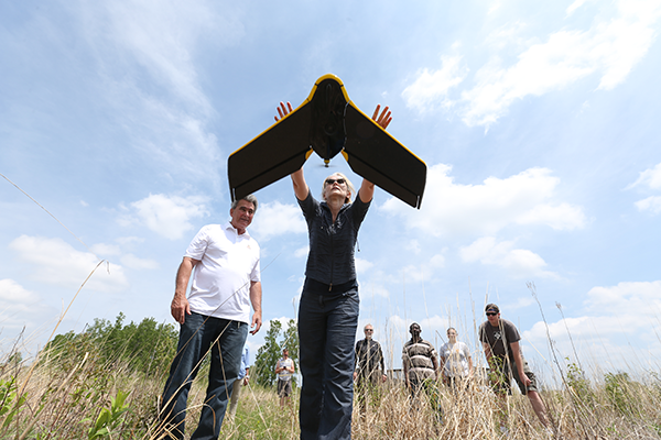
Dr. Anita Simic, a geology faculty member in the School of Earth, Environment, and Society, is a firm believer in engaging her students in scientific exploration. And for her there is no better way to demonstrate the power of science than to explore the concept of remote sensing using a drone.
Simic, who is ready to officially pilot an FAA-approved drone, said she is excited to connect the concept of using cutting-edge technology to advance science, specifically in remote sensing, her field of expertise.
Throughout the summer, she learned the regulations and the techniques to operate a drone for use in water and land monitoring using remote-sensing technologies.
The use of a drone for her research provides more accurate and consistent information because it operates on Global Positioning System coordinates. The drone also can reach areas that are not easily accessible by humans, which is proving especially helpful for the work she is doing in the Western Basin of Lake Erie, Simic said.
One of the issues she is exploring is suspended sediment transportation in the Maumee River. She is measuring the suspended sediment, with variabilities in water, to decide what the satellites can see. The idea is to find precision, or the uncertainties of satellite imaging versus the information collected through the drone.
In addition to NASA Glenn hyperspectral data, the drone is used to monitor land use along Lake Erie to identify hot spots for fish and connect fish abundance and distribution with land use.
“We collaborate with the University of Toledo, Ohio Department of Natural Resources and NASA on this project,” Simic said.
During the summer, she had help collecting the data from a graduate student and an undergraduate. She anticipates involving other students in this state-of-the-art technology. Her teaching philosophy is based on the idea that students need to be equal partners in the learning process.
“My experience while working at the Canada Centre for Remote Sensing and in environmental consulting provided me with many real-world examples that I keep passing to my students to help them grasp the material and enjoy learning,” Simic said.
Remote sensing uses satellite imaging to detect what is happening on Earth, she explained. The beautiful, colorful images of Earth’s surfaces based on remote sensing are possible only after scientists apply models and assign colors to the data.
“The science behind that includes analyzing the numbers and assigning colors; it is art and science at both levels,” Simic said.
Simic likes to introduce the concept of remote sensing in the basic environmental science class. “It’s a relatively new field in environmental studies, a new approach,” she said. “Remote sensing is what allows us to study climate change, ice caps, water quality.”
Simic is a member of America View, a nationwide partnership of remote-sensing scientists who support the use of Landsat and other public domain remotely sensed satellite data through applied remote sensing research. The consortium is comprised of university-led, state-based consortia working together to sustain a network of remote- sensing scientists, educators, analysts and technicians. The primary goal is to support and advance the beneficial uses of remote sensing in service to society.
One of Simic’s goals is to increase the number of students involved in remote sensing at BGSU. “The job demand is good. This type of knowledge is important to companies and agencies that are looking at environmental issues,” she said.
Whether the issues are oil spills, crop production or water quality, remote sensing is an important tool for dealing with these societal concerns.
For Simic, the combination of being able to teach and do research provides a comfortable balance. “I enjoy educating young people and being able to teach hard science and make it easily understandable.”
For the past three summers, she has organized an international remote-sensing conference in Croatia and Greece called the Spatial Literacy (SPLIT) Summer School. Representatives from universities, research institutions and private firms interested in strategies to protect natural resources and public well-being gathered to advance state-of-the-art remote sensing technology, sophisticated and comprehensive modeling approaches, data analysis and sophisticated software capabilities.
Next spring, thanks to Simic’s efforts, BGSU will host a remote-sensing workshop on campus.
Updated: 12/02/2017 12:35AM