Geography Undergraduate Programs
Geography is a broad discipline that bridges the physical and social sciences to study the location, distribution and spatial relationships of human and non-human activity across the globe. Geographic topics include, but are not limited to: human relationships with the natural environment, meteorology, climatology, global and regional climate change and the greenhouse effect; land use; resource distribution and use; geospatial technology, including GIS (Geographic Information System/Science), remote sensing and geospatial statistics; studies of population and settlement patterns; global, regional and urban economic developments; location analysis of commercial and industrial facilities and services; and domestic and international studies that emphasize geopolitical structures.
The use of the GIS has significant impact in areas such as telecommunications, marketing, insurance, education transportation, economics, immigration, emergency preparedness and response, military intelligence, national security, public health weather forecasting, climate prediction, and environmental conservation. Graduating seniors who possess a fundamental understanding of the spatial dimensions of human activity and have strong geospatial technology skills are highly sought after in the marketplace.
The program is designed around the department's focus on the spatial analysis of regional change and development. In this context, the concept of a "region" is defined as a spatial unit that may include both urban and rural areas. Within the department's focus, the primary emphasis is on applied human geographic dimensions of resources, land use, population, and socio-economic analysis. Spatial analysis techniques of computer mapping, GIS, and remote sensing are also emphasized and integrated. All geography majors are advised to take a course in statistics.
Bachelor of Arts in Geography
Minors: Geography, Broadcast Meteorology
Visit the College of Arts and Sciences Geography page for details.
FEATURED

Renovated Moseley Hall Re-opens as Science Complex
When it re-opens after a major renovation in Fall 2017, Moseley Hall will contain laboratory classrooms for the departments of Geology, Chemistry, Biology and Medical Lab Science.
News and Stories
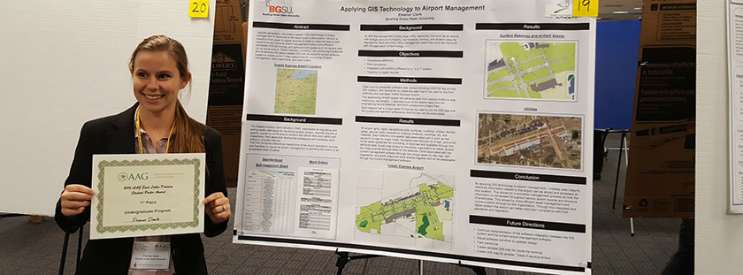
Applying GIS Technology to Airport Management
Ellie Clark, senior Geography major, won first prize for Best Undergraduate Poster at the joint West Lakes/East Lakes Division of the American Association of Geographers meeting at Northern Michigan University in Marquette, MI. The title of her poster was “Applying GIS Technology to Airport Management.” Clark is an undergraduate research assistant at the Center for Regional Development (CRD), and the project is a collaboration between Clark and Dr. Russell Mills, a research fellow in the department of Political Science who is also at the CRD.

Johnson-Webb on Team Studying Infant Mortality
Ohio ranks third in the nation for high mortality rates for Black children, behind Mississippi and Louisiana. Locally, the statistics are equally concerning. In Lucas County between 2015-2017, the Centers for Disease Control and Prevention reported mortality rates for Black infants were nearly three times higher than for white infants.
A team of Bowling Green State University researchers from political science, geography and the Center for Research and Development and several community partners are working together to reduce the infant mortality rates in northwest Ohio and beyond.
BGSU, the Hospital Council of Northwest Ohio (HCNO), its Northwest Ohio Pathways HUB and ProMedica Health Systems have been awarded an Ohio Third Frontier grant to improve infant mortality rates in the state.
The $270,000 grant is authorized by the Ohio Department of Higher Education in support of Ohio Gov. Mike DeWine’s initiative to “highlight the importance of home visitation programs to improve infant mortality rates in Ohio.” read more
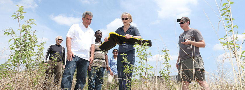
Using Drone Technology in Remote Sensing Science
For Dr. Anita Simic, there is no better way to demonstrate the power of science than to explore the concept of remote sensing using a drone. The use of a drone for her research provides more accurate and consistent information because it operates on Global Positioning System coordinates. The drone also can reach areas that are not easily accessible by humans, which is proving especially helpful for the work she is doing in the western basin of Lake Erie. “We collaborate with the University of Toledo, Ohio Department of Natural Resources and NASA on this project,” Simic said.
Learning Outcomes
Upon completion of the baccalaureate degree, students in Geography are expected to be able to:
- Know and apply geographic concepts in identifying, analyzing, and explaining spatial/global issues and processes;
- Identify and analyze the past and present processes that contribute to the world's constantly changing cultural and physical environments;
- Ascertain the interrelationships and interactions between and among regions;
- Collect, integrate, analyze, display, and communicate spatial information and data sources by using mapping skills, Geographic Information Systems (GIS), and other tools and techniques such as air photo interpretation, remote sensing, statistics, and computers;
- Apply spatial dimensions in analyzing issues and determining how human perceptions and actions contribute to distinct global identities and regional variations.
Accreditation and/or Program/Cluster Review
Bowling Green State University [BGSU] is accredited by the Higher Learning Commission. BGSU has been accredited by the Higher Learning Commission since 01/01/1916. The most recent reaffirmation of accreditation was received in 2012 - 2013. Questions should be directed to the Office of Institutional Effectiveness.
The Geography program will undergo Program/Cluster Review during the Academic Year 2019-20.
Professional Licensure (If applicable)
Bowling Green State University programs leading to licensure, certification and/or endorsement, whether delivered online, face-to-face or in a blended format, satisfy the academic requirements for those credentials set forth by the State of Ohio.
Requirements for licensure, certification and/or endorsement eligibility vary greatly from one profession to another and from state to state. The Geography program does not lead to professional licensure.
Gainful Employment (If applicable)
Under the Higher Education Act Title IV disclosure requirements, an institution must provide current and prospective students with information about each of its programs that prepares students for gainful employment in a recognized occupation.
The Geography program is not a recognized occupation that requires a Gainful Employment disclosure.
Updated: 03/11/2024 03:31PM